
![]()
About Trans Canada Trail
Trans Canada Trail ( hereafter TCT ) is recreational trail connecting the coast of Pacific Ocean and coast of the Atlantic Ocean and coast of the Arctic Ocean.
The course plan was created in 1992 to celebrate 125th anniversary of the founding of Canada. TCT is designed for five activities; walking, cycling, horseback
ridind, cross-country skiing, and where possible, snowmobilng. Approximatery three-quaters of Canadian's population live within a fifteen-minutes drive of
access to the trail. The developement started 1993. This course is 16,000 kilometers long. And this is the longest trail in the world.
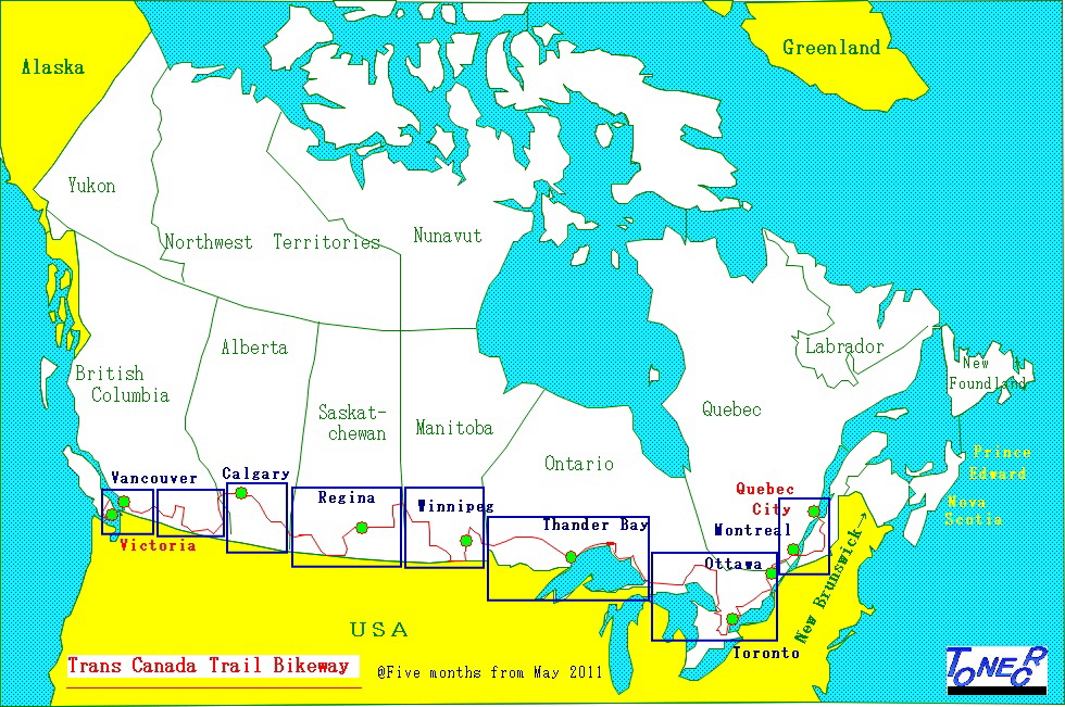
About my cycling in this course
I have reported the state of developement of the longest bikeway in Japan twice a year more than ten years in my home page. Next I wanted to report the
longest bikeway in the world, and I traveled that course on my bicycle in 2011. My course plan was from Victoria to New Foundland, omitting the way to
the Arctic Ocean. But it took much time to cycle on the course, I could not travel whole route.I decided to go along the city or town described in the official
book of Trans Canada Trail published in 2000. I could not buy detailed guidebook, but only one guidebook for the province of British Colombia. For the
gidebook of the other provincias, I deciced to look for it in the actual place. As a result, I used Backroad Mapbooks. For the actual rule of investigation of
the course, I wanted to decide it after looking the course condition, and there is a some inconsistency until establishment of the rule.
The investigatin report was carried on the cycling magazine New Cycling in japan during 14 monthes.
Basic rules of the investigation is as follows;
1) Go along the city or town descrived in the oficial book of Trans Canada Trail
2) In case of planed route of the city or town has already finished, go on that route.
3) In case of planed route of the city or town has not fixed, go through the road connecting between planed citys or towns.
4) If there is a dangerous place, go by a roundabout route
5) If there is a difficult place for the bicycle carrying 45 kilograms of load, go by a roundabout route.
6) I f there is some problems for the weather, place to stay at night, or the itinerary, go by a roundabout route.
7) If the road is too difficult to go for bicycle ride, go by a roundabout route.
8) If there occurs a trouble, take a best way to resolve it. If necessary, go forward leaving TCT route.
My impression about TCT route
1) Almost all route is a gravel road
2) The status of development differs among the provincias
3) The TCT route is decribed in Backroad Mapbook, but I could not know the state of development. There are quite a few ways only for walker.
4) If the timing of cycling does not match with the time to cut grasses, bicycles can not go on the TCT route.
5) In the big city, there is a good cycling road, but in many case road between the cityes go through a mountain road or a footpath where cars don't want to go.
6) In case TCT route is intermittent, it takes a lot of time to seek an entrance of TCT route, as it has a small entrance.
7) The vacant lot of railway is used for TCT route. There are some places removing a track. Even there are some area seem to be waiting for discontinuing a line.
8) I have great esteem for the parsons who created such a great plan seeing far ahead the future,and the persons who are developing it for a long time.